Des stations météorologiques mobiles ont été installées sur plusieurs ferries dans l'État de Washington. Les stations mesurent paramètres météorologiques le long de leurs routes à proximité de Puget Sound, où auparavant de telles données étaient indisponibles. Les stations météorologiques sont intégrées dans le système de suivi des ferries déjà existant, et se composent ; d'une centrale d'acquisition de données CR10X et de capteurs de température, de pression atmosphérique, d'humidité relative et de vitesse et direction du vent. Le mouvement du ferry rend la mesure de la vitesse et la direction du vent particulièrement délicate. Les données précises de vent sont obtenues en corrigeant la lecture des données avec le gyrocompas du ferry et un GPS. Ce projet a été réalisé par Meteor Communications Corp.
---
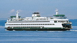
The Washington State Ferry System (WSF) is the largest ferry system in the United States. The 29-vessel fleet makes over 500 trips per day, facilitating transportation of commuters, tourists, vehicles, and goods to islands and peninsulas throughout Puget Sound.
Weather systems in the area move from the Pacific Ocean across western Washington, with wind speed and direction on the waters of Puget Sound being influenced by the Olympic and Cascade mountain ranges. Surface winds are often deflected or funneled contrary to the barometric flow of the systems. Personal observations of pilots, Washington State Ferry captains, and other mariners have shown weather conditions on the Sound to be vastly different, at times, from those being recorded by National Oceanic and Atmospheric Administration (NOAA) shoreside sensors, and by four buoy stations in the area operated by the National Weather Service.
In an effort to make meteorological data from the Sound available to the public, the Washington State Department of Transportation funded the installation of weather stations on seven of the ferries. The stations measure meteorological parameters along the ferry routes and provide ferry operators and the general public with data for more accurate weather reports and forecasts. The stations provide meteorological data where such data was previously unavailable due, in part, to the unique geographic and environmental features of the region.
In 1995, The University of Washington, School of Marine Affairs established the Smart Forum, instituting a means for federal, state, and local regulators to exchange information with marine operators, managers and the general public about safe marine transportation in Puget Sound. The involvement of Campbell Scientific, Inc., in placing weather stations on the ferries, was a direct result of the Smart Forum.
The weather stations were integrated into the already existing Fleet Location System (FLS), a real-time ferry tracking system used by the WFS to maintain the exact locations of each ferry and coordinate scheduling. Meteor Communications Corporation (MCC) provided the FLS with Campbell Scientific equipment and in turn integrated the weather stations into the FLS systems of the ferries.
Each station consists of a CR10X datalogger which measures air temperature, barometric pressure, relative humidity, and wind speed and direction sensors. A Global Positioning System (GPS) provides global position coordinates, vessel speed over ground and course over ground. A gyrocompass (GYRO) provides the actual vessel heading. Data from the GPS, GYRO and CR10X are input to a MCC-545A RF modem, which corrects the measured wind speed and direction using the vessel speed, heading and course over ground. The RF modem outputs the corrected wind speed and direction back to the CR10X for display on the panel, then transmits a data report. The data are displayed to the ferry captain on the vessel itself through use of an LED display panel interfaced to the CR10X. Data are also delivered to a Washington State Ferry workstation, and are available for dissemination to the NWS and the University of Washington, in addition to being posted to the Washington State Ferry web page for public use.
During periods of high winds and maximum tidal currents, some ferries are prevented from safely landing at, or departing from, their terminal slips. With a single delay causing dramatic concern for thousands of commuters, the installation of weather stations on some ferries and transmission of the subsequent real-time data fills a critical gap in the ever-changing puzzle that is Puget Sound weather.
The content of this case study was obtained (with permission) from the following sources. The reader is referred to these documents for a more complete discussion of the application and the methods used:
- Richard J. Fulthorp, BSEE, Meteor Communications Corporation, (MCC) Software Engineering, “Washington State Ferry Mobile Weather Station.” Copyright January, 2000.
- Joseph Nortz, Washington State Ferries, and Jay Creech, Meteor Communications Corporation, “Puget Sound Wind Speed Data Collection System.” Copyright August, 1999.
Sommaire
Application
Meteorological monitoringLieu
Puget Sound, Washington USAContributeurs
Richard J. Fulthorp, BSEE, Meteor, and Joseph Nortz, Washington State Ferries, and JayOrganisations participantes
Université de Washington et le Washington State Department of TransportationParamètres mesurés
Vitesse et direction de vent, pression atmosphérique, température et humidité relativeDispositifs contrôlés
CR10XVoir le document PDF